 By Bobby Rahm · August 9, 2026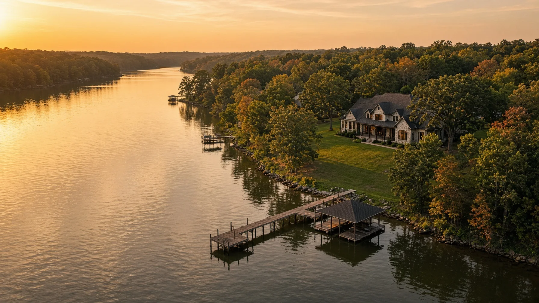
A waterfront home is not just a house near water. Buyers want to understand how the home, yard, shoreline, dock, access route, neighboring properties, and the water itself fit together. Ground-level photography can show finishes and outdoor spaces, but it often cannot explain those relationships clearly.
That is where a well-planned drone shoot becomes useful. The goal is not to collect a random set of high-altitude pictures. The goal is to build a visual sequence that answers the questions a serious buyer is likely to ask before scheduling a showing.
The National Association of REALTORS reported in 2026 that listing photos remain one of the most useful features for online home shoppers. For a waterfront property, the strongest aerial images are usually the ones that provide context rather than simply looking dramatic.
Start With the Property-to-Water Relationship
The first priority is a clean establishing image that shows the entire home site and the water in one frame. This should make it easy to see whether the home sits directly on the shoreline, across a road from the water, above the water on a bluff, or behind another structure.
A useful establishing image should include:
- The home and primary yard
- The shoreline or water edge
- The dock, pier, boathouse, or launch area when present
- The main access road or driveway
- Enough neighboring context to understand the setting
This image should be high enough to explain the property but not so high that the house becomes a tiny object in the frame. A lower oblique angle often works better than a straight-down image because it keeps the home recognizable while showing depth and distance.
Show the Shoreline Clearly
Waterfront buyers often want to understand the character of the shoreline. Aerial photography can help show whether the edge is sandy, rocky, wooded, bulkheaded, sloped, or landscaped.
Useful shoreline views include:
- A diagonal view running along the shoreline
- A view from over the water looking back toward the house
- A side angle showing the transition from yard to shoreline
- A closer contextual image of steps, paths, seawalls, or retaining features
These images should document visible conditions without making technical claims. A drone photo is not a boundary survey, flood determination, engineering report, erosion study, or guarantee of water depth. Captions and listing language should remain descriptive.
Photograph the Dock, Pier, or Boathouse in Context
A dock can be one of the most important features of a waterfront listing, but a tight ground-level image may not show how it connects to the house.
Plan at least three dock-related images:
- A wide image showing the dock in relation to the home
- A medium image showing the full dock, slips, lifts, or covered sections
- A return view from over the water toward the shoreline and house
When boats, personal watercraft, or vehicles are present, decide before the shoot whether they improve the scene or create clutter. The pilot must also avoid unsafe flight over people and moving vehicles unless the operation qualifies under applicable FAA rules.
Show the Route From the House to the Water
One of the most valuable images may be the simplest: a view that shows how someone actually gets from the house to the shoreline.
For some properties, the route is a level lawn. For others, it may involve a long stairway, wooded path, retaining wall, road crossing, or steep slope. Buyers need that context.
A good route image can show:
- Deck or patio exit
- Yard slope
- Steps or pathways
- Gates or fences
- Distance to the dock
- Any visible road crossing
Do not use perspective tricks to make the water appear closer than it is. Wide-angle lenses and aggressive cropping can distort distance. The strongest marketing image is attractive and honest.
Include Outdoor Living Areas
Waterfront homes are often marketed around outdoor use. Drone images can connect patios, pools, fire pits, decks, screened porches, outdoor kitchens, and lawn areas to the water view.
A practical sequence includes one image from behind the home looking toward the water and one from over the water looking back at the outdoor spaces. This two-way approach helps buyers understand both the view from the home and the appearance of the property from the shoreline.
Keep the scene prepared. Remove trash cans, loose hoses, pool-cleaning equipment, temporary toys, construction debris, and vehicles that block important features. Existing preparation guidance for standard home listings still applies, but waterfront properties also benefit from clearing docks, securing loose cushions, and checking that flags or covers are not tangled by wind.
Capture the Water Approach
An image from farther out over the water can be especially useful when the home has a recognizable shoreline presence. This view can show the house, dock, tree line, neighboring development pattern, and general setting.
The pilot must maintain visual line of sight and operate within applicable airspace and altitude limits. Under Part 107, commercial real estate photography is a non-recreational operation. The FAA requires certificated remote pilots to follow Part 107 rules, check airspace, avoid careless operation, and obtain authorization when required in controlled airspace.
A dramatic water approach should never require the pilot to fly beyond visual line of sight or ignore changing wind, glare, boat traffic, or low-flying aircraft.
Add One Straight-Down Context Image
A top-down image can help explain the arrangement of the roof, yard, shoreline, dock, driveway, and accessory structures. It is especially useful when the lot has an unusual shape.
However, a straight-down photo should not be presented as a survey or used to draw precise boundary lines unless a qualified source provides the boundary data and the overlay is clearly labeled as approximate. Trees, lens distortion, terrain, and camera angle can all make visible edges look more definite than they are.
Use the top-down image as context, not proof.
Show Nearby Amenities Carefully
Aerial photos may help show nearby marinas, community docks, beaches, boat ramps, parks, or neighborhood amenities. These images can be useful, but they require care.
Before including an amenity:
- Confirm that it is relevant to the property
- Avoid implying private access unless access is verified
- Do not make unverified distance or travel-time claims
- Avoid flying over crowds or active traffic
- Obtain permission where required for launch or landing
A labeled overview may be appropriate when the relationship is accurate, but it should not exaggerate proximity. If an amenity is several miles away, a separate image or map may communicate it more honestly than a compressed aerial angle.
Plan for Light, Wind, and Water Glare
Waterfront photography is highly sensitive to weather and sun angle. Midday sun can create harsh glare on the water, while low sun may produce attractive reflections but reduce detail in the shaded side of the home.
A pilot should evaluate:
- Wind speed and gusts near open water
- Sun direction relative to the house
- Reflections and glare
- Haze or humidity
- Boat traffic
- Fast-changing weather
Morning or late-afternoon light often provides better shape and depth, but the best time depends on the direction the home faces. A west-facing shoreline may look strongest late in the day, while an east-facing property may benefit from morning light.
Night or twilight operations have additional FAA requirements. Part 107 pilots flying at night must meet applicable training and lighting rules, and controlled-airspace authorization may still be required.
Verify Airspace Before the Appointment
Waterfront homes are often near airports, seaplane routes, military areas, parks, dams, or other sensitive locations. A property owner’s permission does not replace FAA airspace requirements.
The FAA’s B4UFLY service provides airspace-awareness information, including controlled airspace, airports, special-use areas, temporary flight restrictions, and other notices. A commercial pilot should also determine whether LAANC or another FAA authorization is required.
Drones that must be registered generally must also comply with Remote ID requirements. A professional operator should be able to explain certification, registration, airspace authorization, and insurance without turning the listing appointment into a technical lecture.
The Essential Waterfront Shot List
For most waterfront listings, request the following core set:
- Hero image showing home, shoreline, and water
- Opposite-angle establishing image
- Shoreline-length view
- Water-to-house return view
- Dock or pier context image
- House-to-dock access route
- Outdoor living area connected to the water
- Top-down property context image
- Wider neighborhood or waterbody context image
- One vertical image suitable for social media
Larger or more complex properties may need additional images for guest houses, separate garages, multiple docks, long driveways, private beaches, boat ramps, or community amenities.
What Drone Photos Should Not Claim
Aerial marketing images are powerful, but they have limits. They should not claim or imply:
- Exact property boundaries
- Guaranteed water depth
- Flood-zone status
- Navigability
- Dock permitting status
- Structural condition
- Shoreline stability
- Legal access rights
- Inspection findings
Those questions require the appropriate records, licensed professionals, government sources, or legal documents. A good listing package uses drone imagery to explain what is visibly present while directing buyers to authoritative sources for technical matters.
Build a Sequence, Not a Collection
The best waterfront listing gallery moves logically. Begin with a strong hero image, then show the property-to-water relationship, access route, dock, outdoor spaces, shoreline, and wider setting. Follow that with ground-level exterior and interior photography.
When every aerial image answers a different question, the gallery feels useful instead of repetitive. That is the real value of waterfront drone photography: it helps buyers understand the property before they arrive.
Frequently Asked Questions
How many drone photos does a waterfront listing need?
Most listings can be explained with roughly eight to twelve distinct aerial images. Complex properties may need more, but repetitive angles add little value.
Can a drone photo show the exact property line?
No. Aerial images can provide visual context, but exact boundaries require survey or authoritative parcel information. Any overlay should be labeled appropriately and should not be presented as a legal survey.
Is drone photography legal for a home listing?
Yes, when the operation follows applicable FAA rules. Real estate photography for a listing is generally a non-recreational operation conducted under Part 107.
Can the pilot fly over the lake or river?
Often yes, provided the flight remains within visual line of sight, complies with airspace rules, and is conducted safely. Local launch, landing, property-access, or site restrictions may also apply.
Should the listing include nearby marinas or boat ramps?
Only when the relationship is relevant and accurately represented. Verify access rights and avoid implying that a public or private amenity belongs to the property.
Source Notes
- Federal Aviation Administration, Certificated Remote Pilots including Commercial Operators: https://www.faa.gov/uas/commercial_operators
- Federal Aviation Administration, Small Unmanned Aircraft Systems Regulations Part 107: https://www.faa.gov/newsroom/small-unmanned-aircraft-systems-uas-regulations-part-107
- Federal Aviation Administration, B4UFLY: https://www.faa.gov/uas/getting_started/b4ufly
- Federal Aviation Administration, Remote Identification of Drones: https://www.faa.gov/uas/getting_started/remote_id
- National Association of REALTORS, How to Maximize Online Visibility for Every Listing: https://www.nar.realtor/news/real-estate-news/sales-marketing/how-to-maximize-online-visibility-for-every-listing