 By Bobby Rahm · August 9, 2026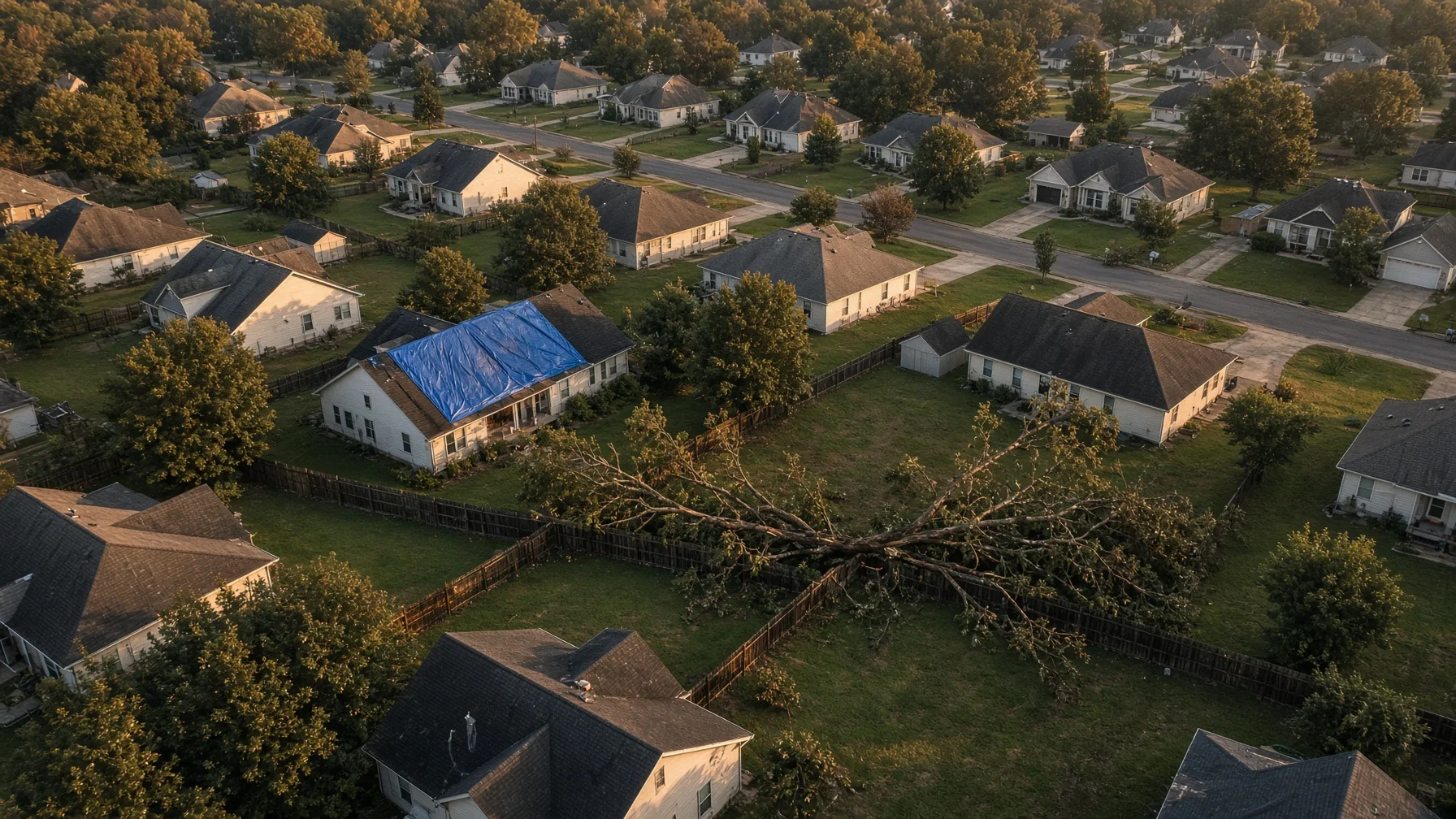
After a major thunderstorm, tornado, hail event, hurricane, or straight-line windstorm, homeowners often need to answer a basic question quickly: what changed?
A roof may look intact from the driveway while missing shingles on the rear slope. A fallen limb may have struck a detached garage that cannot be seen from the street. Water may be pooling behind the house because a downspout, fence panel, or drainage path shifted. Drone photographs can help create a broad visual record of those conditions without placing someone on a wet ladder or unstable roof.
That does not make a drone a substitute for an adjuster, roofer, structural engineer, electrician, arborist, or emergency responder. An aerial image can show visible conditions. It usually cannot determine the cause of hidden moisture, confirm structural integrity, identify every hail strike, or decide whether a loss is covered by insurance.
The best use of a drone is documentation: showing the location, extent, and visible pattern of damage so the homeowner, insurer, and qualified repair professionals can understand what needs a closer look.
Safety comes before photography
Do not enter a damaged property simply to collect better pictures. Stay away from downed power lines, unstable trees, damaged utility equipment, standing water near electrical systems, gas odors, leaning walls, and structures that may collapse.
A drone should also stay grounded when emergency aircraft or first responders are working nearby. The FAA warns drone pilots not to fly in or around disaster-response efforts because helicopters and other aircraft may be operating low, sometimes in reduced visibility. Temporary Flight Restrictions, or TFRs, may be established after hurricanes, wildfires, hazardous incidents, or other emergencies. The FAA requires pilots to check current NOTAMs and TFRs before flight.
Even when no TFR appears on a map, an operation must not interfere with emergency activity. A homeowner who hires a drone operator should expect that operator to postpone the job if fire, police, utility, rescue, or aviation crews are still actively working in the area.
In practical terms, documentation begins after the immediate danger has passed—not while the emergency is unfolding.
Contact the insurer before assuming what it needs
The Consumer Financial Protection Bureau advises property owners to contact the appropriate insurance company after a disaster and to take pictures or videos of damage when possible, including before and after repairs they perform themselves. The National Association of Insurance Commissioners similarly recommends listing damaged property and taking photographs and video when filing a homeowners claim.
Those recommendations support careful documentation, but every policy and claim process is different. Before ordering a specialized drone survey, ask the insurer or agent:
- Has a claim number been assigned?
- Does the insurer want photographs uploaded through a particular portal or app?
- Should visible damage be left undisturbed until an adjuster arrives?
- What temporary repairs are expected to prevent additional damage?
- Does the insurer need estimates, receipts, serial numbers, or contractor reports in addition to photographs?
- Are there any restrictions on entering or photographing the property?
Drone images may supplement the claim file. They do not guarantee coverage, prove the value of a loss by themselves, or replace the insurer’s inspection.
What aerial photographs can document well
A well-planned flight can show relationships that are difficult to capture from the ground.
Roof surfaces and roof components
Useful views may show:
- Missing, lifted, or displaced shingles
- Exposed underlayment or roof decking
- Damaged ridge caps
- Debris resting on the roof
- Bent or detached gutters
- Displaced flashing that is visible from the air
- Damage around vents, skylights, chimneys, and roof-mounted equipment
- Different conditions on front, rear, and side slopes
A drone camera may reveal a pattern that deserves closer inspection. It cannot reliably confirm that every dark spot is hail damage, measure moisture below the surface, or certify that a roof is watertight.
Trees, limbs, and impact paths
Overhead and angled images can show where a tree fell, what it contacted, and how debris is distributed. That record can be useful before removal crews cut and move branches.
Photographs should not delay removal when a tree threatens people, utilities, roads, or an occupied structure. Emergency stabilization takes priority.
Siding, trim, windows, and exterior walls
Oblique views can show damaged siding, loose fascia, broken windows, missing shutters, displaced trim, and areas where wind-driven debris struck the building. A complete set should include every side of the home rather than only the most dramatic damage.
Detached structures and property features
Aerial coverage can document garages, sheds, barns, docks, fences, gates, pools, solar arrays, retaining walls, driveways, and other exterior features included in the assignment. Coverage under a policy is a separate question.
Drainage, standing water, and debris patterns
Wide views may help show blocked drainage paths, ponding water, washouts, displaced landscape materials, and the direction debris traveled. These images can help a contractor understand site access and conditions, but they should not be presented as an engineering drainage study unless a qualified professional performs that work.
Build a photo set that someone else can understand
A useful storm-damage record should be organized like evidence, not like a highlight reel.
Begin with wide establishing images. Show the full property and surrounding context from several directions. Then capture each side of the home and each major roof slope. Follow with closer views of visible damage, while preserving enough background detail to show where that damage is located.
For each image group, record:
- Property address
- Date and approximate time
- Name of the photographer or drone operator
- General direction of view
- Building or feature shown
- Short description of the visible condition
- Whether the image was taken before or after a temporary repair
Keep original files. Avoid editing that removes context, changes the apparent condition, or overwrites capture information. Basic copies for annotation are useful, but the unaltered originals should remain available.
A simple folder structure works well:
- Property overview
- Roof — front slope
- Roof — rear slope
- Roof — left and right slopes
- Exterior walls and windows
- Trees and debris
- Detached structures
- Drainage and standing water
- Temporary repairs
- Follow-up or completed repairs
Use filenames that identify the sequence and subject, such as 2026-07-30_014_rear-roof-missing-shingles.jpg. Consistent naming matters when dozens or hundreds of photographs are involved.
Photograph undamaged areas too
People naturally focus on the worst damage, but a complete record should also show nearby areas that appear unaffected. FEMA training materials for damage documentation emphasize the value of both pre-disaster and post-disaster images, and flood-adjustment guidance notes that undamaged and pre-existing conditions are also important to photograph.
For a homeowner, that means capturing the full roof rather than only one torn section, every exterior elevation rather than one wall, and adjacent structures that help establish scale and context.
When safe and practical, older listing photographs, home portraits, construction-progress photos, inspection reports, or routine property images may provide useful pre-storm context. They should be dated and identified accurately. Do not claim that an old image proves a condition it does not clearly show.
Drone photos should be combined with ground-level records
Aerial coverage is strongest when paired with close ground photographs, written notes, and documents.
The claim file may also include:
- Interior water damage photographs
- Photographs from windows, porches, or ground level
- A written timeline of when the storm and damage were noticed
- Receipts for temporary repairs and emergency services
- Contractor estimates
- Adjuster communications
- Roof, HVAC, solar, or structural reports
- Prior inspection and maintenance records
- A home inventory for damaged personal property
The NAIC recommends maintaining a home inventory and preserving receipts and other proof related to repairs and belongings. Drone images usually document the building exterior and site; they do not replace a room-by-room contents inventory.
Know the limits of visual interpretation
A common mistake is labeling every visible irregularity as storm damage. Roofs may have prior repairs, staining, age-related wear, manufacturing variation, algae, foot traffic, or old impact marks. Trees may have decay or earlier breakage. Fences and outbuildings may already have been leaning.
A responsible drone report uses neutral wording:
- “Three shingles appear displaced on the rear slope.”
- “A large limb is resting on the detached garage roof.”
- “Standing water is visible along the east fence line.”
- “The gutter is separated from the fascia near the northwest corner.”
It avoids unsupported conclusions such as:
- “The storm totaled the roof.”
- “This is definitely hail damage.”
- “The house is structurally unsafe.”
- “The insurer must cover this.”
Those decisions require the appropriate professional, policy review, or claim investigation.
Before-and-after flights can be more useful than one flight
A single post-storm flight documents the visible condition at one point in time. A second carefully matched flight can show temporary stabilization or completed repairs.
For comparison, the operator should try to repeat:
- Camera direction
- Approximate altitude and distance
- Roof-slope coverage
- Image sequence
- Lighting conditions when practical
- Filename structure
The CFPB advises taking pictures before and after repairs performed by the homeowner. A matched aerial series can extend that idea to the roof and exterior, provided the flight is legal and safe.
Questions to ask a drone photographer
Before hiring someone, ask:
- Will the flight be conducted under the correct FAA rules for paid work?
- Will the operator check controlled airspace, NOTAMs, and TFRs?
- What happens if emergency activity, weather, or site hazards make the flight unsafe?
- Will I receive the original full-resolution files?
- Will the images be labeled by side, slope, or feature?
- Can the operator capture both broad context and close visible details?
- Does the service include interpretation, or only photographic documentation?
- How will private images of my home be stored, delivered, and deleted?
- Can a follow-up flight repeat the same views after repairs?
The answers should be specific. “We will get some roof shots” is not a complete scope.
A practical homeowner checklist
Before the flight:
- Confirm the property is safe to enter
- Contact the insurer and start the claim when appropriate
- Identify emergency operations or local restrictions
- Give the operator the exact address and requested areas
- Share known hazards, including wires, unstable trees, animals, and damaged structures
- Explain any privacy or access limits
During documentation:
- Capture the entire property before close details
- Photograph all roof slopes and exterior sides
- Include undamaged context
- Record the date, view direction, and subject
- Avoid disturbing damage solely for a better picture
Afterward:
- Preserve original files
- Make a backup outside the damaged property
- Upload only the images requested by the insurer
- Keep repair receipts and written communications
- Document temporary and completed repairs
- Ask qualified professionals to evaluate conditions that photographs cannot resolve
Frequently Asked Questions
Can drone photos prove that a storm caused roof damage?
They can document visible roof conditions after the event and may help show location and extent. They usually cannot prove causation by themselves, particularly when prior roof condition is unknown. Insurers and qualified inspectors consider additional evidence.
Should I fly my own drone immediately after a tornado or hurricane?
Not when emergency response aircraft or crews are operating nearby. Check current FAA restrictions and local conditions. The FAA specifically warns drone pilots not to interfere with disaster-response activity.
Are drone photos accepted by homeowners insurance companies?
Many insurers accept digital photographs as part of a claim file, but requirements vary. Ask the insurer how images should be submitted and whether an adjuster or contractor inspection is also required.
Can a drone replace a roof inspection?
No. It can capture visible exterior conditions and reduce the need for preliminary ladder access. A qualified roofer, adjuster, engineer, or other professional may still need to inspect the roof or building directly.
Is it useful to photograph the home before storm season?
Yes. Current exterior photographs can help establish pre-storm condition and make later comparisons easier. They should be dated, stored securely, and supplemented with maintenance records and a home inventory.
Source Notes
Federal Aviation Administration — Severe Weather and Natural Disaster Preparedness
https://www.faa.gov/air_traffic/flight_info/hurricane_season
Federal Aviation Administration — Temporary Flight Restrictions
https://www.faa.gov/uas/getting_started/temporary_flight_restrictions
Federal Aviation Administration — Operating Near Hurricane Recovery Efforts
https://www.faa.gov/air_traffic/flight_info/hurricane_season/operating-near-hurricane-recovery-efforts
Consumer Financial Protection Bureau — What should I do after a disaster to protect my finances and property?
https://www.consumerfinance.gov/ask-cfpb/what-should-i-do-after-a-disaster-to-protect-my-finances-and-property-en-1513/
Consumer Financial Protection Bureau — Get prepared before a disaster or emergency strikes
https://www.consumerfinance.gov/consumer-tools/disasters-and-emergencies/get-prepared-before-disaster-emergency-strikes/
National Association of Insurance Commissioners — What You Need to Know When Filing a Homeowners Claim
https://content.naic.org/article/what-you-need-know-when-filing-homeowners-claim
National Association of Insurance Commissioners — Home Inventory
https://content.naic.org/consumer/home-inventory
Ready.gov — Document and Insure Your Property
https://www.ready.gov/collection/document-insure-property