 By Bobby Rahm · August 9, 2026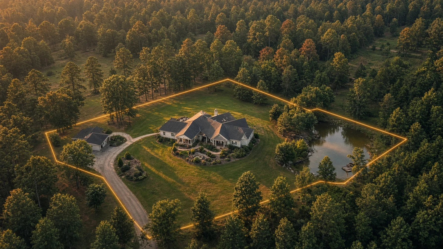
An aerial photo can show the shape and setting of a residential property better than almost any ground-level image. It can reveal how the driveway connects to the road, where a detached garage sits, how a pond relates to the house, or how much of a wooded tract lies behind the lawn.
The difficult part begins when someone asks: “Can you put the property lines on it?”
The honest answer is yes—with an important limitation. A photographer can place approximate parcel lines over a drone image, but the finished graphic is usually a marketing illustration, not a legal survey. That distinction matters. A clean overlay can help buyers understand a listing. An overconfident or poorly labeled overlay can create confusion about ownership, setbacks, easements, fences, and access.
For most residential listings, the goal should be clarity without false precision.
What A Property-Line Overlay Actually Is
A property-line overlay is a graphic added to an aerial image after the flight. The editor may use a county parcel viewer, assessor map, recorded plat, survey provided by the owner, visible monuments, or a combination of those sources to estimate where the parcel boundary belongs in the photograph.
The line does not come directly from the drone camera. A normal real-estate drone image records visible features: roofs, driveways, trees, fences, roads, water, fields, and terrain. Parcel boundaries are legal and mapped concepts that must be aligned to those visible features during editing.
That alignment is rarely perfect. Camera angle, lens perspective, terrain, tree cover, outdated base imagery, and imperfect parcel data can all affect placement. Even when a county parcel viewer appears precise, it should not automatically be treated as survey-grade evidence.
The U.S. Geological Survey describes county parcel viewers as useful secondary sources for researching structures and property information. USGS also warns that map boundaries and Public Land Survey System representations are not legally authoritative records. In practical terms, a parcel map can be useful for orientation while still being unsuitable for deciding where to build a fence or settle a boundary dispute.
When An Overlay Is Most Useful
Boundary graphics are especially valuable when the property’s important features are difficult to understand from the ground.
Large residential lots and acreage listings benefit because buyers can see the approximate relationship among the home, road frontage, woods, open fields, ponds, barns, and neighboring parcels.
Irregularly shaped parcels benefit because the lot may extend behind another tract, narrow near the road, or include a separate access strip that is not obvious in ordinary listing photos.
Properties with multiple structures benefit because a single aerial view can show which buildings appear to sit within the marketed parcel.
Waterfront and rural properties benefit because the overlay can help orient viewers to shoreline, trails, tree lines, pasture areas, and access points.
New construction lots can also benefit, particularly when the home is not yet complete and buyers need context for the building site. However, marketing overlays should never replace a builder’s site plan, recorded plat, setback review, or professional survey.
What An Overlay Should Never Claim
A residential marketing image should not say or imply that an approximate line is a surveyed boundary unless a licensed surveyor’s work is actually being presented and the use is authorized.
It should not be used to determine whether a fence is on the line, whether a shed encroaches, whether a driveway crosses an easement, or whether a tree belongs to one owner or another.
It should not be used as the basis for construction, excavation, landscaping, drainage work, or a property dispute.
It should not hide uncertainty. If the source data is approximate, the graphic should say so plainly.
A simple label such as “Approximate property boundary for marketing reference only—not a survey” is usually more useful than a long legal paragraph buried elsewhere. The label should appear on the image or immediately beside it, not only in a photographer’s private notes.
The Best Source Material, In Order
The strongest workflow begins with the best available property information.
- A recent boundary survey supplied by the owner
A current survey can provide the clearest source for an overlay, but the photographer still needs to translate a flat survey drawing into a perspective aerial image. That translation can introduce visual error. The finished marketing graphic should therefore remain labeled as an illustrative overlay unless the surveyor has prepared or certified the specific presentation.
- A recorded plat or subdivision map
A plat may clearly show lot shape, dimensions, roads, common areas, and easements. It can be very useful for confirming the overall geometry of a parcel. It may not show current visible conditions, and the photographer should not interpret legal details beyond the document’s obvious purpose.
- A county assessor or parcel viewer
County parcel viewers are convenient and often sufficient for a general marketing guide. Their lines may be based on tax mapping rather than field-surveyed positions. Different map layers can also appear slightly offset from current aerial imagery.
- The deed or legal description
A deed can confirm the described parcel but may be difficult to convert directly into a visual overlay without surveying knowledge, bearings, monuments, or GIS tools. A photographer should not pretend to resolve a complex legal description.
- Visible site features
Fences, hedges, roads, tree lines, utility corridors, and mowing patterns can help an editor orient the image, but they do not prove ownership. A fence may sit inside a boundary, outside it, or along an agreed line that differs from mapped data.
How Sellers And Realtors Can Prepare
Before the drone appointment, collect the most reliable documents available. A survey, plat, parcel identification number, county map link, and clear notes about the property are more useful than telling the photographer to “follow the fence.”
Identify the features that buyers need to understand. These might include road frontage, a second driveway, a detached workshop, a pond, a wooded rear section, or a narrow access strip.
Disclose uncertainty early. If the seller does not know whether an old fence follows the line, do not ask the photographer to draw the boundary directly on that fence.
Decide where the overlay will appear. Some listings need one clearly labeled aerial graphic, while others benefit from two versions: a clean hero image without lines and a separate orientation image with approximate boundaries and labels.
Confirm local MLS requirements before publishing. MLS systems may have rules about image alteration, text, branding, disclosures, parcel identification, or media order. The National Association of Realtors’ MLS policy requires a property address where one exists, or other identifying information such as a parcel number or sufficient legal description when an address is unavailable. Local implementation can vary, so the listing agent should confirm the applicable rules.
What The Drone Pilot Should Do
A commercial real-estate flight is generally conducted under FAA Part 107. The pilot should hold a current Remote Pilot Certificate, use a properly registered and Remote ID-compliant aircraft when required, check airspace, and obtain authorization before operating in controlled airspace.
The FAA’s LAANC system can provide near-real-time authorizations at eligible airports and altitudes, but an authorization does not remove the pilot’s responsibility to check weather, temporary restrictions, people on the ground, and other operating conditions.
For a boundary-overlay assignment, the pilot should capture images that make orientation easier. Useful angles often include:
- A near-vertical overview showing the lot’s overall shape
- A lower oblique view showing the house and road frontage
- A reverse angle that reveals the rear of the property
- A wide context image showing neighboring roads or landmarks
- Additional views of outbuildings, water, access points, and wooded areas
The pilot should avoid unnecessary flight over nonparticipants and moving vehicles. FAA rules allow some operations over people and vehicles only when specific aircraft and operational conditions are met. A careful residential shoot normally plans camera positions to reduce that exposure rather than treating the property as an unrestricted airspace bubble.
How To Make The Graphic Clear Without Making It Misleading
Good overlays are simple. The line should be visible against trees, roofs, grass, and pavement without overwhelming the photograph. Labels should point to genuinely useful features, not turn the image into a cluttered map.
Use a consistent line style. A solid or dashed boundary can work, but the legend should clearly explain what it represents.
Use neutral wording. “Approximate parcel boundary” is better than “exact property line.”
Keep important structures visible. The overlay should not cover the roof, driveway, or main landscape features.
Show uncertainty when necessary. If one section is obscured by trees or the parcel data does not align, the editor can use a lighter segment, a question note, or a broader label rather than forcing a false point of precision.
Do not add unsupported measurements. Acreage, frontage, and dimensions should come from listing documents, public records, a plat, or a survey—not from eyeballing the drone photo.
Preserve an unmarked original. The seller or agent should receive the clean aerial image along with the edited overlay. This makes the media more flexible and preserves a source image that is not dependent on a particular interpretation of the parcel.
Questions To Ask Before Ordering A Boundary Overlay
Ask the photographer what source will be used for the line placement. “County GIS” is a reasonable answer when the purpose and limitations are understood. “I can tell from the fence” is not enough.
Ask whether the image will include an approximate-boundary disclaimer.
Ask whether the package includes both marked and unmarked versions.
Ask who is responsible for supplying the survey, plat, parcel number, or county map.
Ask how revisions are handled if the seller or agent notices that a line does not match the supplied documents.
Ask whether the photographer is operating under Part 107 and whether airspace authorization is required for the address.
The Practical Bottom Line
Drone photography can make a residential property easier to understand, and boundary overlays can be especially effective for acreage, rural homes, waterfront tracts, and unusually shaped lots. Their value comes from orientation—not legal certainty.
The safest and most useful approach is straightforward: use the best source material available, label the boundary as approximate, keep a clean original image, avoid unsupported measurements, and direct buyers to the survey, plat, deed, or other controlling documents for legal questions.
A good aerial overlay answers, “How is this property laid out?” It should never pretend to answer, “Where is the legally enforceable boundary on the ground?”
Frequently Asked Questions
Can a drone determine exact property lines?
No. A standard photography drone records images and location data, but it does not by itself establish a legal boundary. Exact boundary work generally depends on legal records, monuments, measurements, and a licensed surveyor’s work.
Are county GIS parcel lines accurate enough for a listing photo?
They can be useful for a general marketing overlay, but they may not align perfectly with visible features and should not be represented as survey-grade boundaries. Label them as approximate.
Should a Realtor publish both a clean aerial image and a boundary version?
Usually, yes. The clean image works better as a hero or gallery photo, while the labeled version helps buyers understand the layout. Providing both also preserves flexibility for MLS and social-media use.
Can a fence be used as the property line in the overlay?
A fence can help orient the image, but it does not prove the legal boundary. Use a survey, plat, parcel viewer, or other documented source rather than assuming the fence is correct.
Does the photographer need an FAA license for listing photos?
A person flying a drone for a real-estate business purpose generally operates under FAA Part 107 and should hold a Remote Pilot Certificate. The flight may also require airspace authorization depending on the location.
Source Notes
Federal Aviation Administration — Certificated Remote Pilots including Commercial Operators
https://www.faa.gov/uas/commercial_operatorsFederal Aviation Administration — UAS Data Exchange (LAANC)
https://www.faa.gov/uas/getting_started/laancFederal Aviation Administration — Part 107 Airspace Authorizations
https://www.faa.gov/uas/commercial_operators/part_107_airspace_authorizationsFederal Aviation Administration — Remote Identification of Drones
https://www.faa.gov/uas/getting_started/remote_idFederal Aviation Administration — Operations Over People General Overview
https://www.faa.gov/uas/commercial_operators/operations_over_peopleU.S. Geological Survey — Authoritative Source: Parcel Viewer
https://www.usgs.gov/core-science-systems/ngp/tnm-corps/authoritative-source-parcel-viewerU.S. Geological Survey — Are PLSS section lines on US Topo maps a legal record?
https://www.usgs.gov/faqs/are-public-land-survey-system-plss-section-lines-us-topo-maps-a-legal-recordU.S. Geological Survey — Why don’t boundaries on US Topo maps match?
https://www.usgs.gov/faqs/why-dont-boundaries-us-topo-maps-match-and-why-are-some-missingNational Association of Realtors — Drones
https://www.nar.realtor/dronesNational Association of Realtors — Current Listings, Property Addresses, Policy Statement 8.9
https://www.nar.realtor/handbook-on-multiple-listing-policy/current-listings-section-20-property-addresses-policy-statement-8-9